
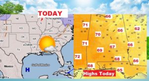
Regardless of what the Ground Hog says this morning, we have a simply beautiful, picture-postcard day ahead of us, on this Super Bowl Sunday. Great grill out weather. We are also starting a warming trend which will take us to into the upper 60’s today, and the 70’s Monday through Wednesday.
But, here’s the trade off. A series of storm systems will drench us from time to time and it looks like we may be dealing severe weather on Wednesday and Wednesday night. Confidence is low. Details below.
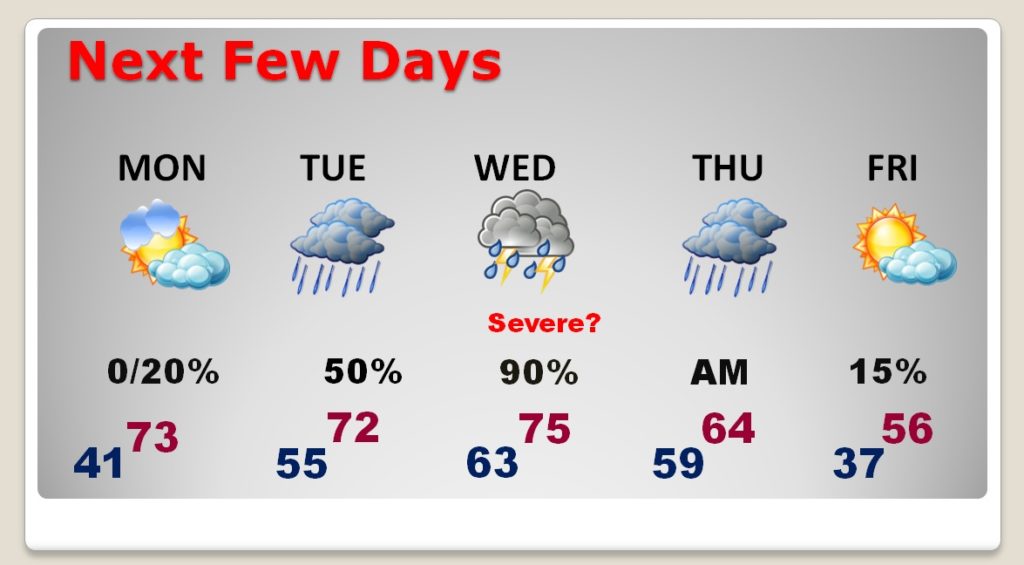
Much cooler air will arrive late week. Friday could be about 20 degrees colder than Wednesday.
TODAY & TONIGHT: Total sunshine will help erase the morning chill. We should be in the 50’s by late morning and into the 60’s after Lunch. Our high should reach the upper 60’s
NEXT FEW DAYS: Monday is dry and warmer, with lower 70’s. Showers could pop up as early as late Monday night. Showers will be around from time to time Tuesday. Showers and thunderstorms could reach severe limits Wednesday. More on the Severe Threat below. Showers will be around for part of Thursday until it turns much cooler, and then colder Friday.
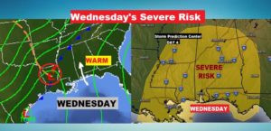
WEDNESDAY SEVERE RISK: Wednesday is a low confidence Severe Weather Risk at the moment. Yes, there will be rich Gulf moisture in place, with temperatures in the 70’s and the dewpoints in the 60’s. However, other details, on the severe weather checkless, are a little muddy right now. The models do not agree on the details. So, how much of severe weather threat, and the potential timeline is yet to be worked out. The Storm Prediction Center has a rather large severe weather threat area outlined on their Day 4 outlook map. We could be dealing with a squall line of strong storms with a damaging wind threat and possibly embedded tornadoes. Stay tuned. I’ll tell you more on my Monday morning video.
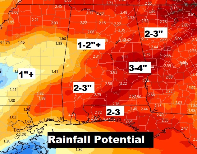
HOW MUCH RAIN?: Depending on how all of this unfolds, rainfall amounts could be rather significant in spots. Many of us could see 2-3”. Some of us could see 3-4”+.
—
In Miami, Florida today, their high temperature will be very similar to the high in Montgomery…with upper 60’s Gametime temperature in the mid 60’s, falling to the low 60’s near the end. Sunshine will dominate. It will be a breezy day. North wind 11 to 21. Clear tonight. Enjoy the game!
I will have a video update for you first thing tomorrow morning. It should be online by about 4:45AM. Have a nice Super Sunday! I plan to fire up the grill.
–Rich