
12:40 PM BREAKING NEWS – UPDATE:
Once again, this weekend, our attention is shifting to yet another enhanced severe weather threat, Sunday and Sunday night.
Some parts of Alabama have had showers and storms overnight, but by a couple of hours after Dawn, the threat of rain, from a weak front moving through the area, will have ended. That front will be a big player tomorrow, as it returns northward as a warm front.
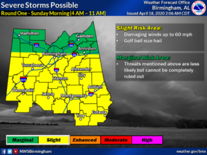
The Sunday Severe threat could come in two rounds. Sunday morning, along the warm front, strong storms could become severe, with damaging wind gusts and large hail possible.
That will probably be followed by a lull for a few hours, before the main Severe Threat gets rolling Sunday afternoon and Sunday night. This round will involve all modes of severe weather, including tornadoes, damaging winds and large hail.
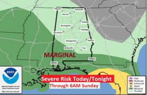
TODAY: Much of this day will be dry and warm with a high 78 to 80. Sun/cloud mix. Another round of showers and storms will enter the state late tonight in the wee hours. Below, is the severe weather threat through 7AM Sunday. It shows a Marginal Severe Risk across SW Alabama in the early morning hours.
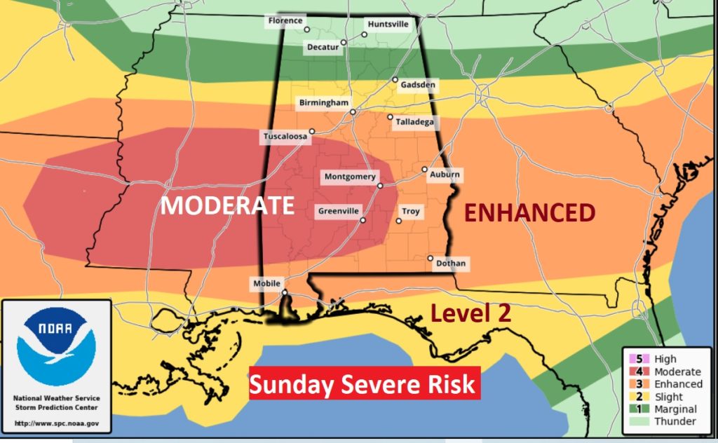
UPDATED Sunday Risk level
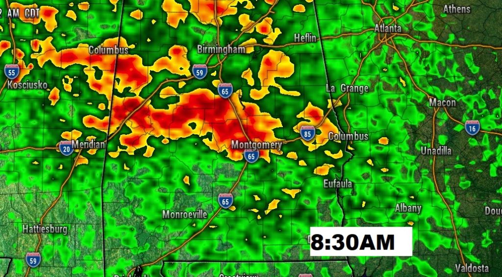
MORNING ROUND?: Potential morning Round one will be along the northward moving warm front. It could begin as early as 3-6AM across SW Alabama and spread northeastward. The main threats would be damaging winds and hail. Perhaps by mid-morning, this threat would be over, likely followed by a lull of a few hours. Here’s one Future Radar scenario Sunday morning showing a lot of strong cells cluster, especially between I-85 and I-20. Don’t take that literally.
The Main Severe Weather Round would begin to take shape during Sunday afternoon into Sunday evening and Sunday night.
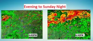
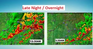
First, ahead of the main line, individual thunderstorm cells could break out in the warm moist air south of the warm front. These storms could become severe and the storms could start rotating, produce tornadoes. Later, the focus will shift to a broken line of storms that will cross the state Sunday evening and Sunday night. Like last Sunday night, this line could produce widespread wind damage, with embedded tornadoes and large hail. NWS mentions a threat window roughly from 2PM to Midnight.
Here’s a few Future Radar snapshots showing how this could or might play out, as far as a potential timeline.
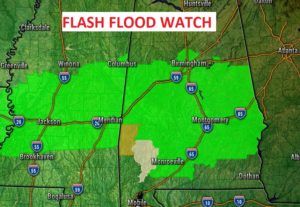
FLASH FLOOD WATCH: The rainfall potential with this system will be much greater than the Easter Sunday storm. A Flash Flood Watch has been issued for central Alabama.
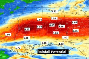
A band of locally heavy rainfall amounts will line up somewhere across central Alabama. Some of the heaviest rainfall totals will be generally along and north of the I-85 corridor. Amounts over 4” are certainly possible, and locally up to 6” in spots.
COMPARING SEVERE WEATHER EVENTS:
Last week’s Easter Sunday outbreak was historic. There were 109 tornadoes across 10 states, with 32 Strong tornadoes, three dozens deaths, and hundreds injured. But here’s what bothers me. There is a danger that some folks might let their guard down with THIS severe weather event. We need to treat this Enhanced to MODERATE risk with great respect. Tornadoes are probable. Loss of life is possible. Damaging winds could be widespread with this system. Do not let your guard down. Be ready to take action and get your family into your safe place.
Wear shoes. If you have helmets…wear them during a warning. You need at least two reliable ways to get a warning. Our weather app could be one. A Weather Radio is a very reliable way to get a warning. It will wake you up when a warning is issued. Do not rely on hearing a weather siren. They are only designed to be heard by those who are outside, and, they sometimes malfunction. Stay in your safe place during a warning. You can watch our LIVE stream on our weather app. Download the App by going to the app store and search Rich Thomas Weather.
WATCH OUR LIVE STREAM: I’m happy to say, our LIVE stream will be much easier locate now. On the Rich Thomas Weather App. Click on the You Tube Tab..and you’ll see Rich Thomas Weather Live stream. You can easily go to this link: richthomasweathernetwork/live on any device or computer. On smart TV’s and ROKU, you can see our Live Stream on You Tube at Rich Thomas Weather. I’ll also be interrupting across the 8 station Bluewater family of radio stations. I’ll also be assisting our friends at the Alabama News Network (CBS 8 and ABC 32). Shane and Ryan and Ben will cut away to me at times.
NEXT FEW DAYS: After the storms move out, pre-dawn Monday, we are in for a quiet series of days Monday, Tuesday and at least daytime Wednesday. But, another round of storms moves in Wednesday night into Thursday. Possibly severe, again.
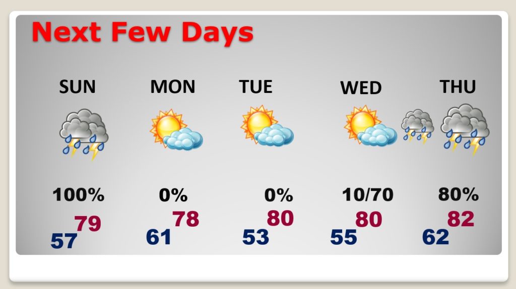
ANOTHER SEVERE THREAT BY THURSDAY: Don’t want to say too much about this yet, but there is another storm system which could produce more severe storms by Thursday. Stay tuned. We have time to watch this system.
– -.
Stay weather aware. I will have another Blog update tomorrow morning. I’ll have additional updates this afternoon as needed. Follow me on Twitter: @RichThomasWX. Stay safe and well.
-Rich